Issue
Breton Sound in Louisiana (in Plaquemines and St. Bernard Parishes, southeast of downtown New Orleans) was one of the areas heavily impacted by Hurricane Katrina in August 2005. To quickly and accurately assess the potential impacts and recovery from the storm, managers needed to have recent land cover information and understand the pre-existing conditions on the ground.
Process
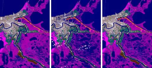
To identify areas of Breton Sound that were impacted by the storm and assess how these areas had recovered by the spring of 2006, NOAA’s Coastal Change Analysis Program (C-CAP) land cover data were used to compare flood conditions in the two-week period following the storm with 2006 conditions. C-CAP provides a nationally standardized source for accurate baseline information. Because all C-CAP data sets (1996, 2001, 2005, and 2006) were created using the same criteria and standards, they can be compared against one another to document changes over multiple years, including the immense land cover changes caused by Hurricane Katrina.
Impact
The most prominent of the changes observed is the dramatic flooding in the weeks following Katrina and the subsequent loss of emergent wetlands. In less than one year, the state experienced a loss of over 150 square miles of estuarine emergent marsh and an increase of over 200 square miles of open water, mostly attributed to Katrina. This information was used to assess Hurricanes Katrina, Rita, and Wilma on fisheries habitat in Texas, Alabama, Louisiana, and Mississippi, and was included in a National Marine Fisheries Service report to Congress. Future land cover updates will help assess longer-term recovery or additional habitat losses.