Northeast States Collaborate on Ocean Mapping Priorities, Garnering National Attention
The Takeaway: A collaborative effort of northeastern states ensures that crucial priority areas of the ocean floor receive thorough mapping attention.
The Northeast Regional Data Prioritization Project, led by the Northeast Regional Ocean Council, is transforming how northeastern states handle coastal mapping. This initiative signifies a shift in regional data prioritization and mapping approaches, setting a collaborative precedent for coastal strategies nationwide.
Member states Connecticut, Maine, Massachusetts, New Hampshire, New York, and Rhode Island have harmonized their mapping strategies, pooling expertise to identify shared priorities and secure funding. Previously, individual state projects struggled to have their mapping needs met—but this collective effort has identified areas of common interest, led to five potential new project proposals, and influenced national priorities by engaging with the Integrated Ocean and Coastal Mapping program. This approach isn’t just about mapping; it’s addressing a spectrum of needs, from wind energy potentials to coastal hazards and archaeological sites, setting a new standard for comprehensive coastal understanding.
Identifying Priorities
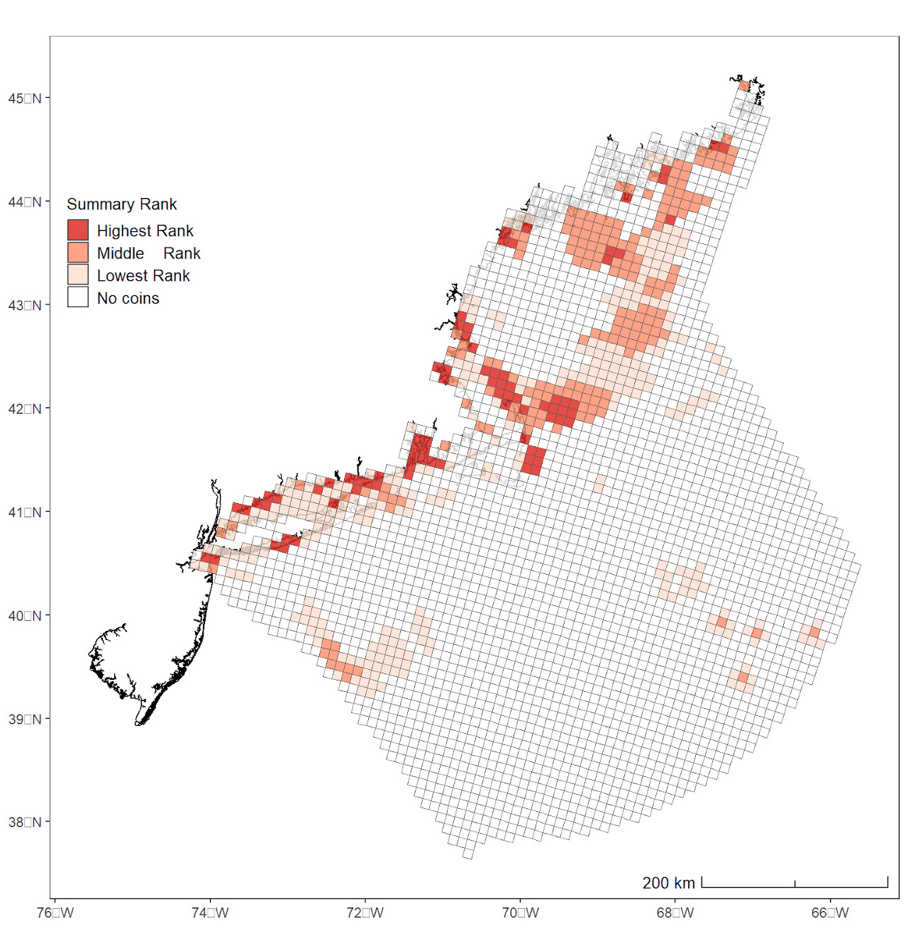
This project hinges on how priorities are identified and projects are chosen for action. Each participating stakeholder group, including states and national government agencies such as the National Marine Sanctuaries, National Park Service, and U.S. Geological Survey, received an allocation of 300 virtual tokens that were used to vote on priority mapping areas. This democratic allocation system helps pinpoint crucial hotspots and facilitates decision-making on where mapping efforts should be concentrated. The initiative involves the use of tools such as the SeaSketch tool and ArcGIS, empowering stakeholders to visualize data gaps and strategically allocate resources.
The Mapping Process
Mapping the ocean involves a variety of technologies and approaches based on the management needs and research questions to be addressed. In deeper, offshore waters this is usually accomplished through use of active sonar systems that operate by emitting sound and analyzing the returning echo. This provides bathymetry and seafloor hardness and roughness. Underwater cameras or grab samples often are used to better understand the acoustic data and gather more detailed information. In shallow, clear waters aerial imagery or lidar can be used as well as acoustics to characterize the seafloor. A project will typically seek to optimize which technologies to deploy and how.
Ideally, resolution for these maps is finer than 10 meters, enabling the identification of boulders and rocks. However, gaps persist in data beyond 30 meters depth, a result of historical methods. Early in the 20th century, ships would sail, drop a lead-weighted line into the water, measure its depth, and repeat the process—turning these measurements into points on a map, depicting varying depths. This antiquated method leaves significant gaps in our understanding of the ocean floor, yet many areas have never been mapped beyond this method.
Challenges
Seafloor mapping is technically and logistically difficult. These challenges, and the cost of seafloor mapping, have resulted in many areas being unmapped or mapped at such low resolution that the data are not suitable for use in management or research. Despite agreeing on priorities, mapping the ocean continues to present formidable challenges—particularly in shallow areas and regions such as the Gulf of Maine, which is subject to harsh weather and the lack of mapping vessels in the region. Additionally, proposed projects involving wind energy and submarine electrical cables raise concerns about environmental impact, demanding thorough mapping efforts to evaluate and minimize potential repercussions.
How Partners May Use These Results
Massachusetts has already used the results to help identify potential partners and funding sources for three projects. The state has been coordinating with Maine and New Hampshire on shared interests in the Bureau of Ocean Energy Management’s draft wind energy area in the western Gulf of Maine. Massachusetts has also been in communication with NOAA’s Office of Coast Survey to see if existing, planned NOAA surveys in Massachusetts Bay and the Gulf of Maine can be augmented and achieve a larger survey footprint with state funds to help meet Massachusetts mapping needs. Lastly, Massachusetts has identified federal partners that may be interested in helping Massachusetts meet some of its state waters mapping needs related to offshore sand management.
Looking Ahead
While the data prioritization project was a one-time effort, the council is considering ways to maintain the process regularly, and Massachusetts has even built a viewer to review the results. The involvement of the Habitat Classification and Ocean Mapping Subcommittee within the council further exemplifies the depth of collaboration, with specific projects, such as the Gulf of Maine Seascapes, demonstrating the ongoing commitment to improving coastal mapping efforts in the Northeast. (2024)
Partners: Office for Coastal Management, National Centers for Coastal Ocean Science, Northeast Regional Ocean Council, Maine Department of Marine Resources, Massachusetts Coastal Zone Management Program