Issue
Sea level rise and its potential impacts to endemic habitats and species are a concern for the Waccamaw National Wildlife Refuge on the South Carolina coast. The refuge includes some of the most diverse freshwater wetland systems in the world and is home to many important wildlife species, including the swallow-tailed kite and black bear. Habitats for these species are already beginning to show signs of saltwater intrusion and other sea level rise–related impacts. Information about how landscapes might change and resulting impacts to habitat quality and connectivity is needed to make informed management decisions.
Process
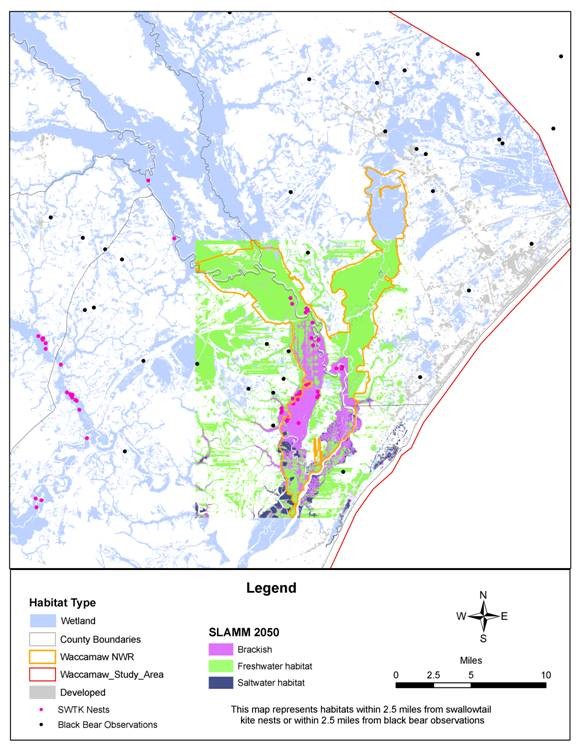
The project team used the Sea Level Affecting Marshes Model (SLAMM) to map predicted distributions of wetlands within the refuge and the nearby North Inlet–Winyah Bay National Estuarine Research Reserve (NERR) if sea level were to rise 1 meter over a 100-year period. SLAMM has typically been run at a regional scale; however, for this study, local accretion rates, tidal information, habitat data, and locally available lidar data were used, resulting in more site-specific marsh migration predictions.
The SLAMM outputs were used with a GIS-based tool to target areas for conservation, including key habitats for the swallow-tailed kite and black bear. Because the SLAMM outputs predict that some of the tidally influenced freshwater wetlands needed by these species will be lost as sea levels rise, existing data on swallow-tailed kite nests and black bear observations were used to help identify inland habitat that may be appropriate for these species as marshes shift. Gap Analysis Project (GAP) land cover data were used in areas where SLAMM outputs were not available.
Impact
The NERR is using the SLAMM results to educate community stakeholders about the trends and types of habitat impacts that could result from sea level rise and to target key areas for long-term monitoring. The refuge and The Nature Conservancy are working with state and local organizations to conserve inland freshwater habitats beyond current refuge boundaries for the swallow-tailed kite and black bear, because existing protected areas will become more brackish with sea level rise. The refuge is also considering expanding its acquisition boundary to be able to continue to study and protect these and other key management species.

