
Issue
Land-based sources of sediment and pollution are a major threat to the health of coral reefs. Protection and restoration of coral reef ecosystems require resource managers to identify watersheds where human activities and modifications to the landscape contribute to reef decline.
Process
The U.S. Environmental Protection Agency (EPA) used NOAA Coastal Change Analysis Program (C-CAP) land cover data and coral survey data to explore the relationship between landscape and coral reef condition in the watersheds of St. Croix, U.S. Virgin Islands. The coral survey followed techniques described in the EPA’s “Stony Coral Rapid Bio-Assessment Protocol” to measure coral condition indicators. Landscape data were derived from 2007 high-resolution (2.4 meter) C-CAP land cover data. A landscape development intensity (LDI) coefficient that relates sources of land-based sediments and contaminants to land cover types in a watershed was applied to each land cover class. The resulting LDI maps highlight watersheds with elevated amounts of human disturbance.
Impact
The study found that high human land-use activity within a watershed is associated with poor coral condition and that LDI maps developed from land cover data are a good predictor of the condition of coral reefs in St. Croix. NOAA C-CAP land cover data provide landscape information critical to the process. This process can be used in other locations where coral reef communities are potentially impacted by human land-use activities. LDI data are used to inform coastal management and land use decision-making.
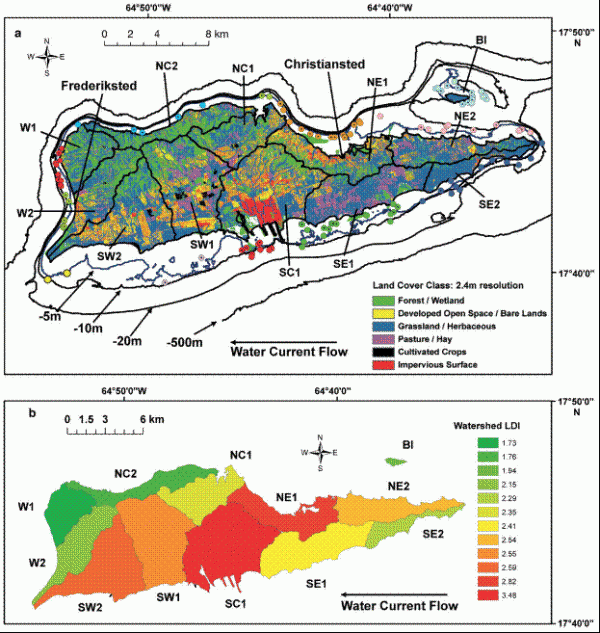
The top figure displays St. Croix watersheds and associated coral stations (circles that share a common color) used to evaluate relationships between human disturbance and coral condition in 2006 and 2007. Station colors are not related to land use.
The bottom figure displays watershed landscape development intensity (LDI) values for St. Croix, where green indicates the lowest human disturbance and red indicates the highest.
Courtesy Oliver, Lehrter, and Fisher, 2011, in Marine Ecology Progress Series article
Additional Information
- View a Marine Ecology Progress Series article to learn more about this project.